
In the days prior to the Bahman 22 anniversary of the Iranian revolution, Khamenei’s forces were making furious efforts to tighten a blindfold on the media so that the world could not see the magnitude of the Iranian opposition. At the same time the opposition movement, with far fewer resources, had to find a way to get the truth out with as little bloodshed as possible.
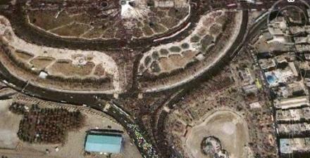
It was during this time that Mark Brender, the Vice President of Communications at GeoEye (www.geoeye.com), an operator of high-resolution Earth imaging satellites, received a call from an unusual customer. A professor at one of Iran’s universities was wondering if a GeoEye satellite would be in position on 11 February, 2010 to take a picture of Azadi Square at the time when Ahamadinejad was giving his 22 Bahman speech.
I spoke with Mr. Brender who received that historic call, and he was eager to read some of the emails he received from grateful Iranians:
“Dear sirs, I want to say thank you, thank you…” signed a Persian member of the Green Movement.” The Green Movement member was thankful that the satellite image showed the area inside Azadi Square as mostly empty, whereas the streets leading to the square were packed with crowds the regime did not trust enough to let inside. That is, potential opposition supporters.
Here’s another email, “You guys are so incredibly awesome for publicly exposing the fascist Iranian regime and its claim to millions of supporters to the critical eyes of the free…” Awesome because the image also suggests that even the regime’s few trusted supporters may not be very committed. The long line of buses to the south of the square shows how the regime was able to gather the few supporters that it did. They were bused to the location in an organized government effort to pack the event.
One more email, “Your image of Azadi Square is a big help for democracy and the Green Movement in Iran. In all social networks people are expressing their appreciation.”
You get the picture, no need to go on.
I asked Mr. Brender how he felt about GeoEye’s role in giving the world an accurate picture of the democracy movement in Iran, and he humbly said, “We were just the photographers.” Yet he obviously understood the significance of the Iranian professor’s request.
In fact, it was GeoEye who contacted Google to let them know there was a “hot” picture available that the whole world would be interested in seeing. Google then loaded the one-meter resolution, IKONOS image to GeoEye’s Google Earth layer and posted the image on their lat/long blog.
Of course it was by no means certain that GeoEye would be able to fulfill the request of the Iranian professor. He wasn’t just asking for any image of Azadi Square, which would have been a cinch for GeoEye. He was asking for Azadi Square at a particular time, a much taller order for a satellite that’s in orbit around the Earth.
There were two elements of luck involved in getting this time-sensitive satellite image. First, Azadi Square had to be clear of clouds at the time of the ceremonies. Bahman is a winter month in Tehran, increasing the likelihood of clouds. Second, one of GeoEye’s satellites had to be in the right place in its orbit at that time.
Mr. Brender explained the timing problem in this way, “The satellites are sun-synchronous, meaning they follow the sun to get optimal light and consistent shadowing on the ground. They are also only overhead mid-morning on any given day. Just imagine, these satellites are flying 681 kilometers above the earth at an average speed of 7.5 kilometers per second. The Earth’s rotation also decides where they are going to be, since the satellites are in a fixed orbit and make 15 orbits per day while the Earth is constantly spinning beneath them.”
Simply put, the task needed Nature’s cooperation.
The weather obviously cooperated. But to appreciate the second element of luck let’s see what odds we were up against relative to the satellite being in the right place. GeoEye operates two high-resolution imaging satellites, and between the two of them they are able to image any point on the planet every 24 to 36 hours. These polar-orbiting satellites can approximately revisit any point on Earth once every three days or sooner (they repeat their exact orbit every 144 days). So, if customers order a desired location they have to wait until the satellite comes around again in its orbit. If this were a poker game you’d have to be holding a two pair to beat the odds of getting a picture within a one-hour window of the desired time.
GeoEye checked the flight path of their newer, higher resolution satellite, GeoEye-1, well in advance of 11 Feb, and it was scheduled to be nowhere near the right place. If it weren’t for IKONOS, GeoEye’s very first high-resolution satellite, the regime would not have been exposed in this way. IKONOS happened to be passing 225 kilometers to the east of Tehran (somewhere on top of Dasht e Kavir) at 10:47 A.M. on that day. Commanding the satellite to tilt its gaze about 20 degrees to the west, GeoEye caught Despotism in an embarrassing moment.
I light-heartedly asked Brender if GeoEye would be sending a bill to the Iranian freedom movement for this image. He said, “No charge.”
Though their images are usually custom-ordered for a fee, there are special public interest circumstances–the Haiti earthquake, for example — where providing free images helps with humanitarian causes, while bringing name recognition to the company. Another way of humbly saying, “We were just the photographers.”
Yet GeoEye gave the public an important photograph that no journalist in the world was able to achieve, all taken from outer space where individual governments don’t have any control.
Please, Pulitzer Prize committee, keep this in mind!
Notes
1. GeoEye is a publicly traded company (NASDAQ: GEOY) and independent of Google Inc. (NYT: GOOG). Google happens to be one of their customers.
2. GeoEye’s “map-accurate” images can help with accurate crowd estimates. For example, each digital pixel in a GeoEye-1 satellite image represents an object on the ground which measures.41-meter resolution, so it’s capable of seeing the home plate on a baseball diamond. It also offers three-meter geolocation accuracy, which means that customers can map natural and man-made features to within three meters of their actual location on the surface of the Earth without ground control points. In this way any area of Azadi Square or surrounding streets can be calculated to high accuracy, and the crowd estimated. To get a scale for headcount per unit area, you can use the satellite photo of, say, the Obama inauguration ceremony and the figure of 1.5 million attendees for that event.
3. Over the years, GeoEye has helped expose many other secrets in Iran. Their GeoEye-1 satellite image of the enrichment facility north of Qom was seen all around the world. As was their imagery of the Natanz nuclear complex.